

Dr. Heinrich Berghaus Physikalischer Schul-Atlas bestehend aus acht und zwanzig in Kupfer gestochenen und colorirten Karten. Ein Auszug aus des Verfassers grossem physikalischen Atlas zum Gebrauch beim Unterricht und zum Selbststudium
Grafik, karta.
Mycket gott skick.
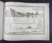
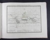
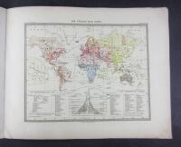
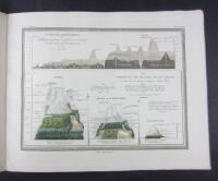
This is Berghaus uncommon Physikalisher Schul-Atlas, a scaled down school version of the famous and grundbreaking thematic larger atlas published 1837-1892. It comtains cutting edge carthography showing the globes heat distribution, air currents, sea currents, rain distribution, land and see ratio, mountain ranges, geological profiles, global vegetation, mountain vegetation, tree distibution in Europe, Bird- and predator spread, population distribution and more
The maps have hand coloured borders as well as some coloured areas
The german map publishing house Justus Perthes, (well known for producing the Stieler Hand-Atlas) was one of the world´s foremost map makers in the 19th century dominating the european market
First edition. Gotha: Verlag von Justus Perthes 1850
Title + 28 maps + 12 pages
Size: 25 x 31 cm
A little foxing and slight soiling to the wrapper. Text and maps in nice condition with som browning an foxing in some margins, and just into a couple of maps